
This footpath report provides an update on the progress of work on the Lancashire Coastal Path.
Coastal Path in Lancashire
Regular readers of these notes will know that the provision of the Coastal Path in the NW started in Cumbria, with the Allonby to Whitehaven section, which opened in Apr 2014. In Feb 2020 the path around Walney Island was opened. Then the Whitehaven to Silecroft section opened in Mar 2021. This was followed by the part from Silecroft to Green Rd that was opened in Feb 2022, this being a sub section of the Silecroft to Silverdale section.
In Jan 2020 a set of reports were published by Natural England about the section from Silverdale to Cleveleys. In June 2021 approval was given to the route in chapters (sub-sections) 2, 4 and 6, but officially the route covered by these chapters are not yet available to walk. The proposed route covered in chapters 1, 3 and 5 are the subject of appeals being considered by the Planning Inspectorate.
Then in Oct 2020 reports were published for the Cleveleys to Liverpool section. In Aug 21 the chapters 4, 5 and 6 which covered the route from Tarleton to Liverpool was approved. In my response to Natural England in early 2021 about this part of the planned route covered by these 3 chapters, I only made comments about small points of detail, which were acknowledged, but when the approval came through the original route was unchanged.
In May 23 the route from Tarleton to Liverpool Pier Head was officially declared to be open, which is a distance of 36.4 miles. The only new access that was created was across the end of Hundred End Gutter. The part from Tarleton Lock to Crossens was the first part of the Coastal Path to be opened in Lancashire.
Recently I walked from Tarleton to Southport, which was a pleasant day, that at my present walking speed took most of the day. It was good to see that all the stiles have been replaced by pedestrian gates, and that an erosion issue that I noted in Dec 16 on Tarleton FP 05 at grid ref SD452222 has been solved by the creation of the Henry Alty Linear Park. It was also good to walk across the end of Hundred End Gutter without seeing any private notices.
What did concern me was the situation at Tarleton Lock. On going down Sutton Ave (post code PR4 6BB – grid ref SD45352168) and reaching the end, are direction arrows, with the right arrow indicating 'Tarleton Lock - No Through Route'. This sign was provided by the parish council. On getting to Tarleton Lock grid ref 45592147 is a sign indicating that this is part of the Coastal Path, and behind it are some Private signs, indicating that people should not go through the boatyard. One wonders when the definitive map (record of public footpaths) was drawn in the 1960s what the intention was ? To effectively have a cul-de-sac path does not seem right. Plox Ave is an Adopted Highway that goes from Hesketh Lane to the banks of the River Douglas, but then the access to the boatyard next to the River Douglas is then along an Unadopted Highway, which means that no access rights exist. Users of the Coastal Path are effectively forced to walk down Sutton Ave in order to get to the Coastal Path.
Does anybody know the history of the land around Tarleton Lock ? I am aware from attending national events when I was the Area Secretary that the canal acts are often ambiguous, but that the later railway acts were more tightly written. It maybe that Tarleton Lock will be added to a list of anomalies that need looking at, if anybody volunteers to research Lost Ways in Lancashire.
The route from Tarleton Lock to Crossens is obvious on top of the flood defence embankment. On the section near Hesketh Out Marsh the route uses the old flood defence embankment. In 1980 Hesketh Out Marsh was enclosed by a new flood defence embankment, which then became a target for the RSPB to buy and restore. In 2007 the RSPB acquired the western part of Hesketh Out Marsh, and they soon created four gaps in the new flood defence embankment, which allowed the tides back in. Ten years later in 2017 they acquired the eastern part of Hesketh Out Marsh and then created four more gaps in the flood defence embankment, to make a total of eight gaps. If you are intending to include bird watching on your walk, you may find that the birds are some distance away, beyond the range of binoculars, for enthusiastic bird watchers seem to have telescopes.
On getting to Crossens it is possible to catch the number 2 bus (Southport to Preston) back to Tarleton. Alternatively it is possible to continue walking on the Coastal Path to Southport. Initially walk on the embankment next to the water course to reach the Marine Drive. Continue along the Marine Drive until you reach the car park for Marshside (RSPB site). Officially the Coastal Path continues along the Marine Drive, but instead take the steps down to the beach, where a path exists, that is parallel to the road, that is more pleasant than walking on the Marine Drive. Until you get to the Pier. Then head inland to Lord St, and catch the number 2 bus.
It is possible to continue walking from Southport to Liverpool in stages and then catch the bus or the train back to your start point, for the locality is served by good public transport.
In a future Newsletter I will write some words about the part from Cleveleys to Much Hoole part of the route, which is now approved, but not yet officially open. In early 2021 this part of the Coastal Path was the subject of several comments from myself and others.

Pedestrian gates have replaced the stiles on the section of the Coastal Path between Tarleton and Crossens.
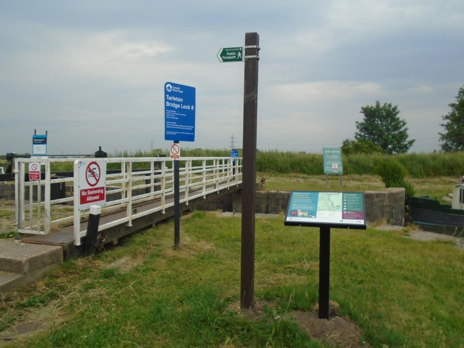
The start of the Coastal Path at Tarleton Lock – and nearby the Private signs.

David Kelly
July 23